
Severe weather on the way
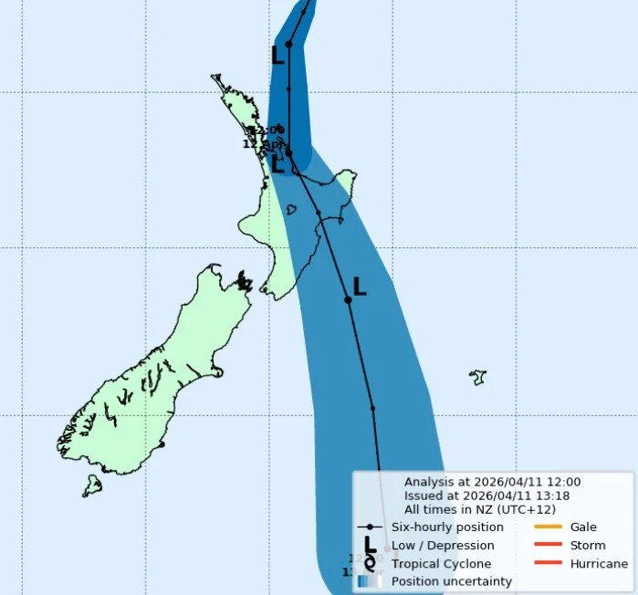
The predicted path of the cyclone at midday on Saturday, April 11. Image: MetService
Taupō people are being advised to prepare for strong winds and heavy rain from early Sunday morning as Cyclone Vaianu looks set to pass down the North Island.
By Dan Hutchinson and RNZ
The centre of the cyclone is forecast to pass close to Taupō, likely east of the district, although its course can change as it works its way down the country.
Tens of thousands of extra people are in Taupō this weekend for the Supercars Championship. Supercars has now cancelled its Sunday events for safety reasons. More details below and at Supercars.com.
Taupō Mayor John Funnell is warning people to prepare early by ensuring there is nothing loose, like trampolines that could fly around and that drains are clear of leaves and other debris.
“Be careful over this coming weekend. We are expecting extremely strong winds and flooding in our district. Be safe,” Funnell said in a public statement.
“Clear drains and gutters, bring in or secure any items, such as bins and trampolines that could get picked up by wind, charge your devices and make safety plans for your household, pets and farm animals.
“It's also a good idea to check on your emergency kit including food, water, torches and batteries.”
Heavy rain can also increase the risk of landslides and flash flooding.
MetService has issued an Orange Strong Wind warning for many parts of the North Island including the Waikato, Waitomo, Taupō and Taumarunui area, from 4am-10pm on Sunday, beginning with severe easterly gales, changing to westerly gales in the afternoon.
Gusts of up to 120km/h could occur in exposed places, the MetService says.
MetService forecast shows Cyclone Vaianu about to make landfall on Saturday morning.
There is also a Yellow Heavy Rain Watch in place for Waitomo, Taumarunui, Taupō and Taranaki, from8am Sunday to 8pm Sunday.
“Periods of heavy rain, and amounts may approach warning criteria.” Says the MetService on its website.
Latest news below
The entire North Island is on alert with Cyclone Vaianu due to hit from Saturday night.
A state of emergency is in force in Northland and lasts an initial seven days.
Local Civil Defence said it was rare to have a region-wide declaration, but it was a precaution given the significant impacts the storm could have.
"This declaration means we can act quickly if required. It gives us the tools to respond effectively and keep our communities safe if the situation escalates," Northland Civil Defence group controller Damian Rio said.
In Bay of Plenty, the Whakatāne District Council could declare a state of emergency on Saturday morning.
"Forecasts indicate potentially dangerous coastal conditions including landslides, storm surge, large waves and coastal flooding, particularly in low-lying coastal areas," it said.
Acting Mayor Julie Jukes said there was a high likelihood that West End at Ōhope would need to be evacuated on Saturday.
"While no evacuation orders are in place right now, we are encouraging residents to prepare - including planning where they could go and packing essential items," she said.
If mandatory evacuations were ordered then Police would knock on doors of all affected residents on Saturday morning.
The council said it had concerns for beachfront properties along Pōhutukawa Avenue, Waterford Estate and Plantation Reserve, and low-lying properties bordering Ōhiwa Harbour such as Liddon Cove and Ōhiwa Parade.
"While self-evacuation is not mandatory for any area within Ōhope at this stage, planning to relocate for up to two days is strongly recommended," it said.
"Were taking this cyclone extremely seriously. Don't wait to be told to go. If anyone, anywhere feels unsafe, relocate as soon as possible."
In Hawke's Bay at Haumoana, people in coastal areas were being told to consider staying with friends or family away from the coast during the cyclone.
Hawke's Bay Regional Council said large waves driven by Vaianu were likely to cause "noticeable" coastal erosion in some areas.
The most exposed beaches were likely to be Mahanga, Haumoana, Te Awanga, Westshore, Kairakau and Pourerere.
"The peak of the swell will be around high tide on Sunday afternoon at 1pm and will continue to impact parts of the coast during high tide on Monday morning at 1.30pm," the regional council said.
It said there was also potential for heavy rain in the ranges, and it was actively monitoring river mouths and pump stations.
Fire and Emergency has decided where to position enhanced rescue teams ahead of Cyclone Vaianu.
These were firefighters with extra rescue skills and specialised equipment, who would support local firefighters.
They were being deployed to Whangārei, Auckland, Rotorua, Tairāwhiti and Coromandel.
FENZ said the teams were mobile and could move elsewhere as needed.
The National Emergency Management Agency is advising people not to wait for official warnings to evacuate.
The agency said when the weather worsened, people needed to act quickly to stay safe and should trust their own "danger sense".
NEMA advised people to leave immediately if they saw floodwaters rising or notice small rockfalls or muddy water, buildings or trees moving, or creaking or rumbling noises.
The agency said acting quickly could save lives.
MetService
MetService Severe Weather Watch
Issued at 9:52am Sat 11 Apr 2026
Cyclone Vaianu expected on Sunday
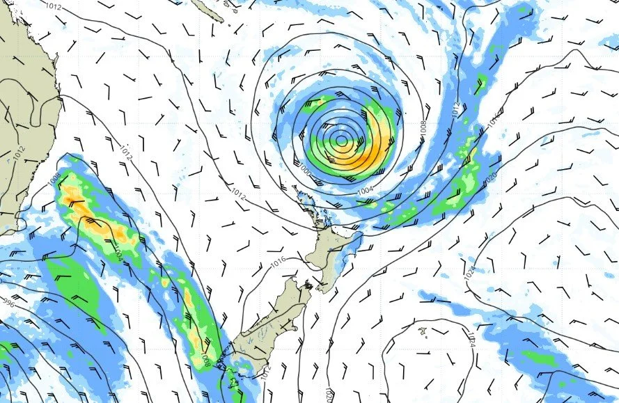
Cyclone Vaianu is expected to move southwards across the North Island tomorrow (Sunday), passing west of the Chatham Islands on Monday. The current track of the cyclone can be found at https://www.metservice.com/warnings/tropical-cyclone-activity.
The combination of damaging winds, heavy rain and coastal inundation makes this a multi-hazard, potentially life-threatening event. The locations of the most severe impacts associated with Cyclone Vaianu, such as power outages, falling trees, flooding, slips, road closures and isolated communities are highly dependent on the cyclone's track.
Strong Wind and Heavy Rain Watches and Warnings are in force for much of the North Island and upper South Island, including the Chatham Islands Sunday and early Monday.
People are urged to keep up to date with the latest forecasts, adjust plans as needed and be prepared to act, following all advice of local authorities.
Heavy Rain Watch
Area: Northland north of Bay of Islands to Hokianga Harbour
Period: 10 hours from 9:00pm Sat 11 Apr to 7:00am Sun 12 Apr
Forecast: Periods of heavy rain, and amounts may approach warning criteria.
Low chance of upgrading to a Warning.
Area: Waikato
Period: 17 hours from 1:00am Sun 12 Apr to 6:00pm Sun 12 Apr
Forecast: Periods of heavy rain, and amounts may approach warning criteria.
Moderate chance of upgrading to a Warning.
Area: Waitomo, Taumarunui, Taupo and Taranaki
Period: 12 hours from 8:00am Sun 12 Apr to 8:00pm Sun 12 Apr
Forecast: Periods of heavy rain, and amounts may approach warning criteria.
Moderate chance of upgrading to a Warning.
Area: Bay of Plenty about and east of Whakatane
Period: 15 hours from 6:00am Sun 12 Apr to 9:00pm Sun 12 Apr
Forecast: Periods of heavy rain, and amounts may approach warning criteria. Large swells and coastal inundation are likely.
Moderate chance of upgrading to a Warning.
Area: Gisborne/Tairawhiti about and south of Tolaga Bay, also coastal hills and ranges of Hawke's Bay excluding the Kaweka and Ruahine Ranges
Period: 16 hours from 2:00am Sun 12 Apr to 6:00pm Sun 12 Apr
Forecast: Periods of heavy rain, and amounts may approach warning criteria. Large swells and coastal inundation are likely.
Moderate chance of upgrading to a Warning.
Area: Wairarapa and the Tararua District, also eastern and southern parts of Wellington, excluding the Tararua Range
Period: 12 hours from 11:00am Sun 12 Apr to 11:00pm Sun 12 Apr
Forecast: Periods of heavy rain, and amounts may approach warning criteria.
Moderate chance of upgrading to a Warning.
Supercars
April 11, noon statement
Supercars confirms ITM Taupō Super 440 Sunday cancellation
Decision made amid expected landfall of Cyclone Vaianu over central North Island
Race 10 of the 2026 season will be rescheduled to Friday in Christchurch
Supercars has made the difficult but necessary decision to cancel Sunday’s event day at the ITM Taupō Super 440, following the deterioration of weather conditions and the expected landfall of Cyclone Vaianu over the central North Island.
The safety of our fans, teams, officials, and all event personnel is the absolute priority for Supercars and all stakeholders involved.
Following consultation with authorities and emergency services, including Motorsport New Zealand, Taupō Emergency Management, Taupō District Council and New Zealand Major Events, Supercars has determined that conditions on Sunday present an unacceptable risk to all in attendance.
Following the state of local emergency for the Waikato region, including the Taupō District, fans are urged to follow the latest MetService warnings and the advice of local authorities.
Race 10 of the Repco Supercars Championship will be rescheduled to Friday, at the ITM Christchurch Super 440. This addition creates a bumper opening day to the first Supercars round to be held on the South Island.
Supercars acknowledges the impact on ticket holders for Sunday. Ticketek NZ will contact affected ticket holders directly in the coming days with information on refund options.
Thank you for your patience and understanding during this time.
Supercars Executive Chair Barclay Nettlefold said: "This is an unprecedented situation that has never occurred in the history of the Supercars Championship.
Advertisement
"It’s very disappointing to see a weather event of this scale disrupt what we had hoped would be an exciting final day of racing.
"We deeply regret the impact this cancellation has on our fans who have travelled to Taupō to be part of this event. But a cyclone of this intensity leaves no other option, and the safety of everyone at the circuit has to come first.
"We’re delighted to be in a position to make it up to fans and all our partners, by adding a race to the Christchurch event."
Supercars thanks all fans, teams, officials, our title sponsor ITM, the team at Taupō International Motorsport Park for their flexibility and understanding.
We look forward to delivering a spectacular event in Taupō next year.
For further updates, please visit Supercars.com or follow @supercarschampionship on social channels.
We thank everybody for their understanding.
Taupō Civil Defence
Saturday, April 11, 12 noon, Facebook post: Here’s the latest on Cyclone Vaianu from MetService.
The strong wind warning that covers Taupō District has been extended from 2am tomorrow morning (Sunday) until 10pm Sunday night. As before, they’re saying severe gale easterlies switching to severe gale westerlies late afternoon or evening.
Up to 120km/h which ain’t going to be great for the perm!
The Heavy Rain Watch from 8am to 8pm Sunday remains unchanged.
A regional state of emergency has been declared across the Waikato Region. A state of emergency gives emergency services and local authorities extra powers to respond quickly if they need to.
All this paru weather may also increase landslide risks. They particularly like to hang around steep areas, banks, cliffs, roadside cuttings and that.
Get your specs on and watch out for these warning signs. See any, don’t muck about! Evacuate if you think the building you’re in could be at risk.
Small slips, rock falls, or sinking ground at the base of slopes
Doors or windows sticking or not closing properly
Gaps appearing around window or door frames
Decks, steps or verandas tilting or pulling away from buildings
New cracks or bulges in the ground, roads, paths, or retaining walls
Trees, fences, or retaining walls starting to lean
Landslides can remain a threat even after rain has eased, so keep your wits about ya!
Find out what to do before, during and after a landslide:
www.getready.govt.nz/landslides
Preparedness advice: https://getready.govt.nz/
Weather warnings and updates: metservice.com/warnings
Taupō Mayor John Funnell, Facebook, April 10, 6.28pm
Please use the Taupō District Council website for up-to-date warnings.
Be careful over this coming weekend. We are expecting extremely strong winds and flooding in our district. Be safe.
Taupō District Council is continuing to monitor Cyclone Vaianu as it moves closer to New Zealand.
It's expected to make landfall on Sunday.
MetService New Zealand have upgraded our district to a Strong Wind Warning for 12 hours from 10am, Sunday 12 April.
The forecast is for severe gale easterlies in the morning, changing to severe gale westerlies in the afternoon, with gusts of up to 120km/h.
We also have a Heavy Rain Watch in place from 8am to 8pm the same day.
Heavy rain and strong winds may cause:
Flash flooding and rapidly rising water
Dangerous driving conditions and road closures
If you haven’t already, now’s a good time to take a few simple steps around home to get ready.
Clear drains and gutters, bring in or secure any items, such as bins and trampolines that could get picked up by wind, charge your devices and make safety plans for your household, pets and farm animals.
It's also a good idea to check on your emergency kit including food, water, torches and batteries.
Heavy rain can also increase the risk of landslides. Warning signs include:
Small slips, rock falls or sinking ground at the base of slopes
Doors or windows not closing properly or gaps appearing around their frames
Decks, steps or verandas tilting or pulling away from buildings
New cracks or bulges in the ground, roads, paths or retaining walls
Trees, fences or retaining walls starting to lean
Evacuate if you think your home or building could be at risk.
More tips for preparing for wet and windy weather https://getready.govt.nz/
Find out what to do before, during and after a landslide:
www.getready.govt.nz/landslides
Planning for farm animals' safety Waikato Rural Support Trust
Keep up with the latest warning info: metservice.com/warnings
Fire and Emergency New Zealand, media release, April 10, 3.37pm
Fire and Emergency New Zealand is preparing for the expected impacts of Cyclone Vaianu.
Deputy National Commander Megan Stiffler says Fire and Emergency has been working with the National Emergency Management Agency (NEMA) and Civil Defence Emergency Management (CDEM) groups since mid-week.
"We have well trained local crews right across the North Island and we will be pre-positioning specialist resources, including enhanced rescue and water rescue teams to support those local crews.
"This is expected to be a fast moving and high intensity storm with a wide area of impact, including areas still recovering from severe weather in March," Megan Stiffler says.
"Flooding, landslides and falling trees can be expected, with consequent impacts on power, communications, and travel.
"We are ready to respond where we are needed, and we have extra resourcing ready to be deployed at short notice."
Megan Stiffler says Fire and Emergency’s advice is to always call 111 when life or safety is at risk.
"Do not drive through floodwater - you are putting yourself at risk and risking the lives of those who come to your rescue.
"In floodwaters you can’t tell how deep the water is, or how swift. The road may have been washed away and there could be hidden obstacles.
"At home, tie or take down trampolines and outdoor furniture and prepare for power outages.
"We recommend using torches and battery powered devices wherever possible to reduce the risk of unwanted fire in your home during a power outage."
For the latest weather warnings follow MetService and follow New Zealand Civil Defence and your local Civil Defence page for emergency warnings and advice.
Supercars, revised schedule statement 2pm Friday
Supercars confirms revised ITM Taupō Super 440 schedule
Schedule changed due to extreme weather forecast to impact New Zealand on Sunday
Regular updates regarding Sunday will be provided throughout Saturday
Supercars has announced changes to the track schedule for the ITM Taupō Super 440, due to the extreme weather forecast to impact New Zealand on Sunday.
This follows careful consideration and consultation with local authorities, consistent meteorology reporting and national advice.
Saturday’s second race has been extended to 200km.
All Saturday race sessions will be moved forward by 30 minutes. The 120km Race 8 will start at 12:20pm NZST. The 200km Race 9 will begin at 3:30pm NZST.
Only the Boost Mobile Top Ten Shootout will be lost from the program.
Race 10 of the Repco Supercars Championship has been tentatively rescheduled for 9.55am NZST on Sunday, a move in line with latest weather forecasts.
All Sunday-only General Admission ticket holders are invited to use their tickets on Saturday and Sunday.
All Sunday Pit Walk ticket holders, will also be invited to attend the Saturday Pit Walk.
Supercars Chair and Interim Chief Executive Barclay Nettlefold says: “We have worked very carefully with local authorities to ensure the utmost safety for our fans, teams and all stakeholders throughout recent days.”
“While we certainly hope to run the event in full, safety and responsibility are absolutely critical.
“Supercars will continue monitoring the situation with great caution over the coming days.”
Regular updates regarding Sunday, will be provided throughout the day on Saturday.
Revised Saturday track schedule notes
All sessions brought forward half an hour on Saturday
Saturday's second 120km race replaced with Sunday’s 200km race
Saturday's first 120km race will now be on Super Soft tyre
Race 9 (late 200km race) will be on Soft tyre
Change of Qualifying format for new Saturday 200km Race
No Top Ten Shootout, as it will not fit in the schedule
Revised Sunday track schedule notes
Tentative Sunday schedule with Supercars Qualifying at 8:00am
Race 10: 120km race (Soft tyre) commencing at 9:55am to finish at 11:08am plus 1 lap
For full schedule, ticketing details and updates, please visit Supercars.com.